.png)
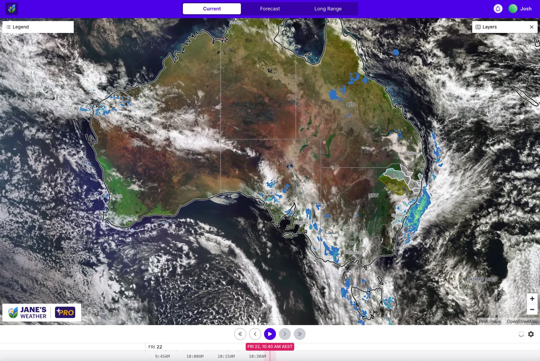
Significant rain (and flooding) over northeastern NSW and southeast QLD is easing on Friday, with the last of it at the coast, no longer with heavy falls. The next weather system is well off the coast and won't be a repeat, and the focus shifts to southeastern Australia next week, bringing a stretch of dry weather (and colder winds later in the period) for the east.
On Friday we have tropical moisture pouring in from the Indian Ocean. That is running into a cold front, which is our equation for rain - moisture plus instability. The problem is, the connection to moisture is weakening, and high pressure is in the way so the cold front slides and the instability weakens. This means that the run of frosty nights and sunny days that graced the southeast this week has ended, but the cloud from the front produces only light and patchy rain.
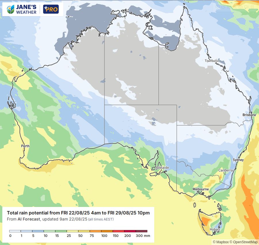
That feed of moisture isn't done. It'll increase again over the weekend, feeding a big weather system in the southwest on Sunday and Monday. Wet weather continues through much of next week as the next high moves in very slowly.
The situation in the southeast dramatically changes from Tuesday onwards. The next high isn't going to sit over Tasmanian latitudes, but up over northern NSW. That means it has much less of a say in what can move through - it's no longer a blocking feature.
Northeast NSW and southern QLD take a well earned break, while the first in a series of fronts arrives in the southeast on Tuesday, with plenty more to follow for the rest of the week. This is enhanced by that feed of moisture - seen on the satellite as a juicy northwest cloudband - and should deliver some nice rain:
Will it last? In short... no.
The weekly anomaly maps indicate that while the southeast is the flavour of the week in 'week 1' (beginning Monday 25th August), it is not for 'week 2' (beginning Monday 1st September). The focus may return to QLD/northern NSW and the southwest.
.gif)
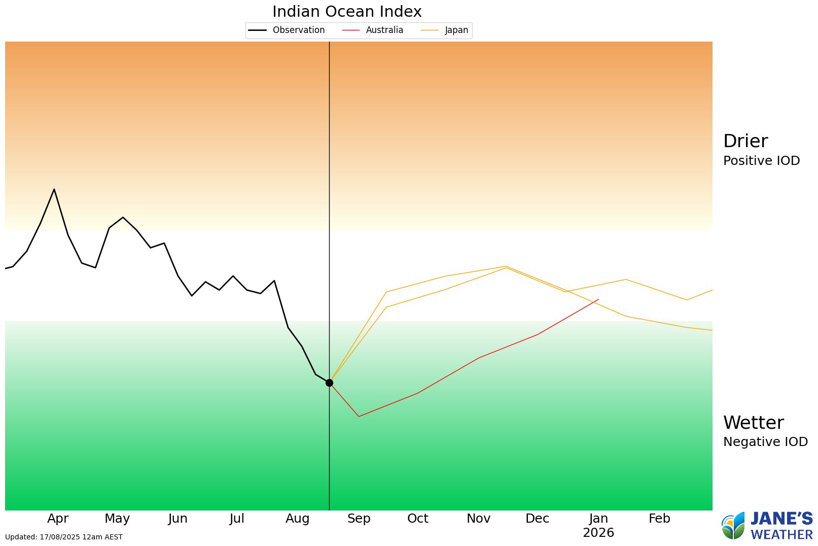
We're now in week four of a Negative Indian Ocean Dipole (IOD). We need to reach eight weeks before BoM declares this year a Negative IOD year.
This will continue to encourage feeds of tropical moisture, but as always it depends on which areas see the low pressure as to which areas get the resulting rain.
If you'd like to be guided through all of this and have 14 minutes to spare, please see my latest video:
In this series I'll take you through the drivers of our weather, highlighting any changes over time and things to watch out for (generally every Sunday). It covers weather elements like temperature and rainfall, and how they are driven by moisture from the Pacific and Indian Oceans, as well as bursts of energy from low pressure (SAM and MJO).
See and hear my commentary as I take you through the weather pattern's effects on our rain and temperatures in detail over the next week, with a brief look at week 2 and beyond as well.
Plus what is driving our weather in the weeks and months ahead, with the latest on El Nino/La Nina, the Indian Ocean Dipole (IOD), the Southern Annular Mode (SAM controls our weather systems), and the Madden Julian Oscillation (MJO connects tropical moisture to our weather systems).
I update this commentary each week, generally on Sundays. Make sure you are signed up (free or a subscription) so you don't miss an update.
Stay up to date with the forecast specifically for your area in our hour by hour outlook for the next 10 days. Download our app for iPhone and Android.
As always, you can see each of these graphics as soon as they update, as well as more information about them under our Rain Outlook and Seasonal Outlook pages within Jane's Update, along with our Snow Forecast in the snow season.

For further insights specifically for agriculture, to improve the utilisation of your resources, tailored to any Australian location, please upgrade your membership. You can take advantage of our free 30 day trial.
Upgrade to see full insights to help plan the best use for your resources:
- frost risk
- spraying conditions
- evapotranspiration to efficiently manage available water for crops
- growing degree days to monitor growth
- full ten day hour by hour outlooks, all variables, and all model data
- customised alert notifications
.png)
.png)
.png)