.png)
The main things to note this week are: significant rain for eastern NSW and southwest WA this weekend, as high pressure crosses the southeast letting conditions warm up. The Indian Ocean crossed the threshold into a Negative IOD earlier this week, while there have been some changes in the Pacific Ocean too that are worth keeping an eye on.
NSW RAIN
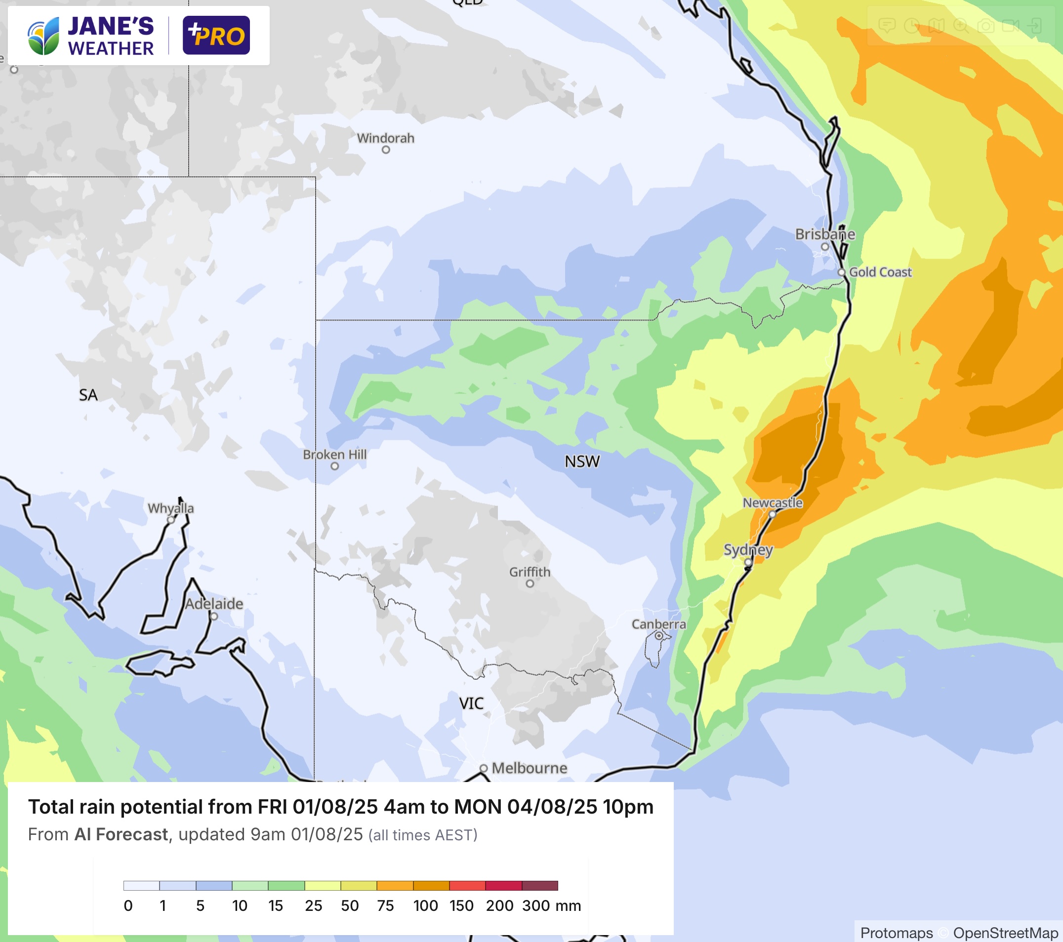
Upper atmosphere energy is letting a low form just off the northern NSW coast, bringing significant rain to those near and to the south of the low.
There is lighter rain inland over northern NSW too, easing as it all moves eastwards. Much of Queensland only sees a little, on the 'dry side of the low'.
Here is the pattern of where the heavier falls should be, before it all eases on Monday as the low moves away:
WESTERN AUSTRALIA
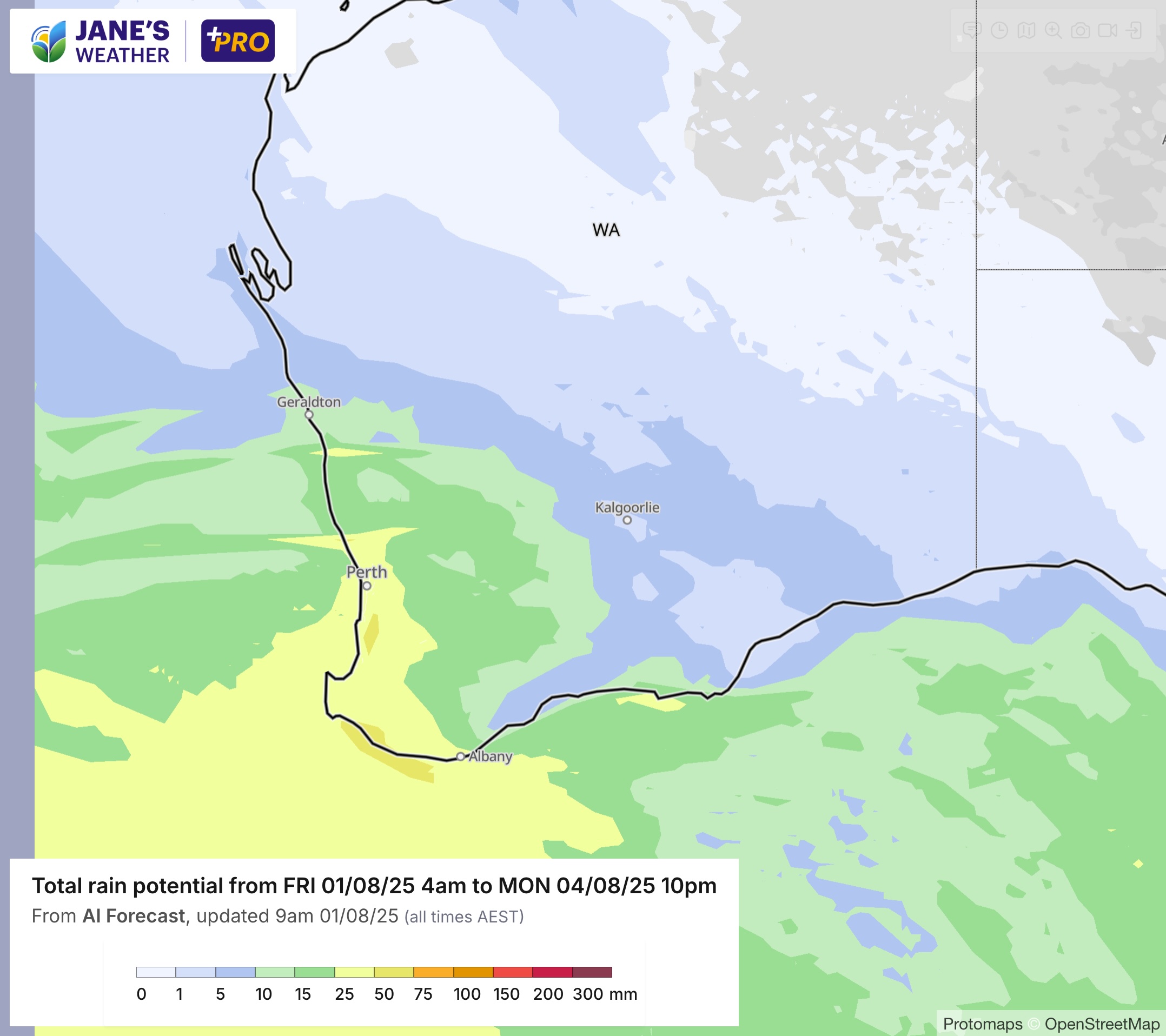
A series of fronts peak in the west this weekend, producing a widespread 25 to 50 mm of rain, and 10 to 25 mm further inland.
This rain comes with gusty winds and the risk of storms, and eases on Monday:
TROPICAL MOISTURE
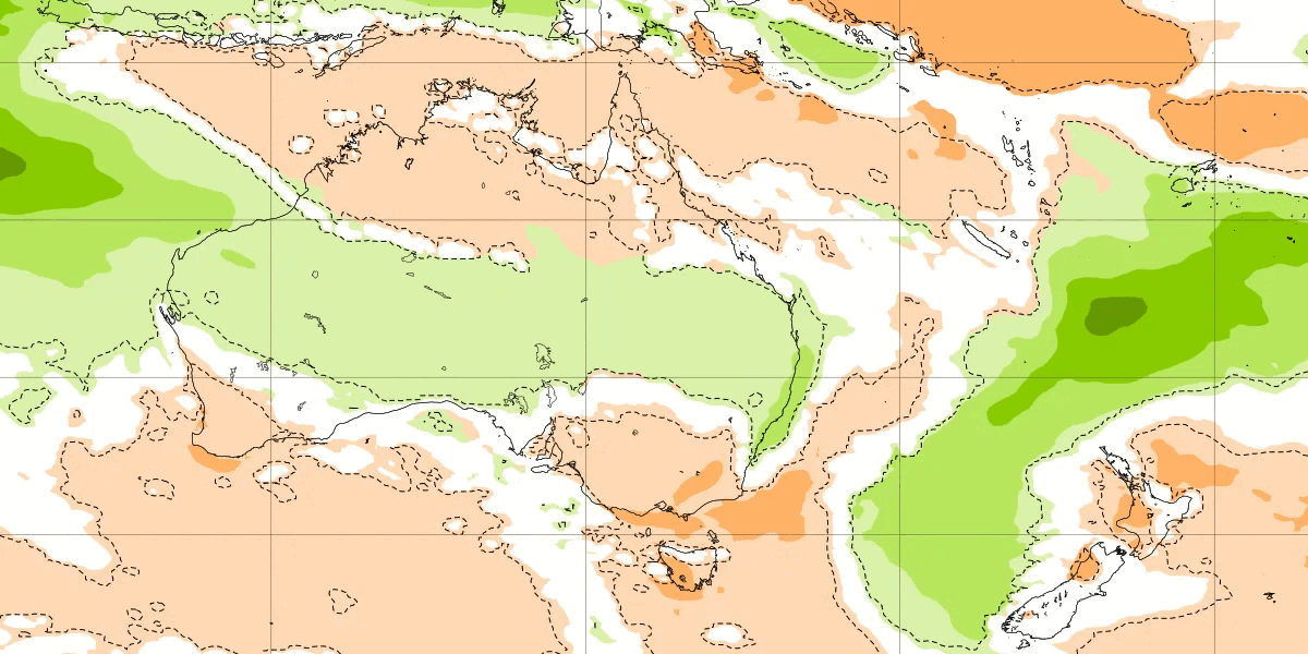
A feed of tropical moisture comes down from the northwest next week, and this will be picked up by a low/trough/front and delivered as significant rain to those in its path.
The first wave of this is likely to take the same path as this weeks: across NSW and southern Queensland. Due at the end of the week.
Again, high pressure blocks this from reaching the southeast, but the high may move over the Tasman Sea (between Australia and New Zealand) letting that moisture slide down into the southeast beyond the end of next week.
The following guidance from the Euro model shows the spread of rain across NSW and Queensland, then how in the next week it could spread down into the southeast. This is on the horizon and one to keep an eye on.
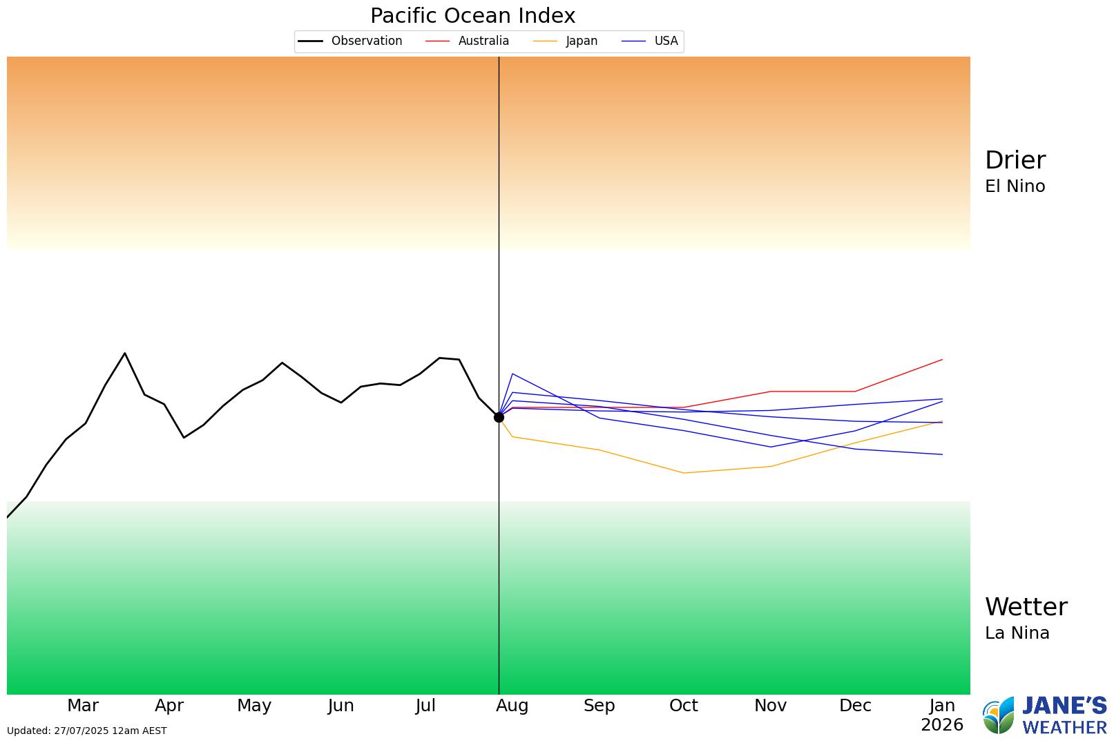
TROPICAL OCEAN INDEXES
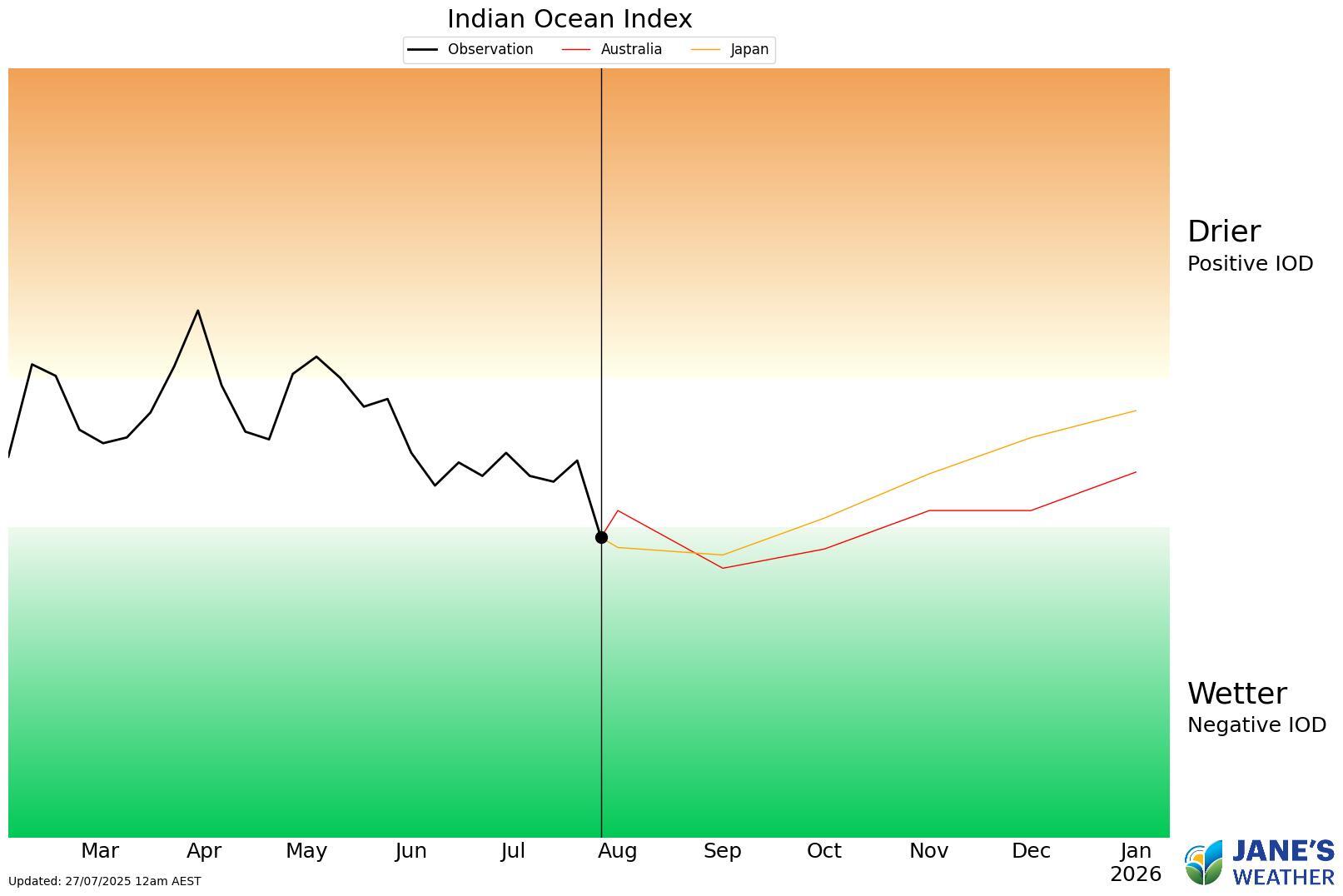
Earlier this week we crossed an important threshold. The Indian Ocean went down into a Negative phase. It will need to be there for 8 weeks to officially be a Negative IOD, and we are at week one - but the forecasting shows it is likely to stay there.
What this does is encourages feeds of tropical moisture to spill down across the country from the northwest.
All we need is for those to run into low pressure to produce significant rain.
The Pacific Ocean has also recently taken a turn.
Still very Neutral, but there are signs of a slight veer in the direction of La Nina - and the Japanese model likes it coming closer to the threshold than the rest of them.
We also have a pool of warm water off the coast of Queensland, that helps send moisture our way too.
So that's two oceans that are trying to increase the rain chances for Australia over the next few months.
For the full in depth update (around 16 minutes this week), don't miss my video:
In this series I'll take you through the drivers of our weather, highlighting any changes over time and things to watch out for (generally every Sunday). It covers weather elements like temperature and rainfall, and how they are driven by moisture from the Pacific and Indian Oceans, as well as bursts of energy from low pressure (SAM and MJO).
See and hear my commentary as I take you through the weather pattern's effects on our rain and temperatures in detail over the next week, with a brief look at week 2 and beyond as well.
Plus what is driving our weather in the weeks and months ahead, with the latest on El Nino/La Nina, the Indian Ocean Dipole (IOD), the Southern Annular Mode (SAM controls our weather systems), and the Madden Julian Oscillation (MJO connects tropical moisture to our weather systems).
I update this commentary each week, generally on Sundays. Make sure you are signed up (free or a subscription) so you don't miss an update.
Stay up to date with the forecast specifically for your area in our hour by hour outlook for the next 10 days. Download our app for iPhone and Android.
As always, you can see each of these graphics as soon as they update, as well as more information about them under our Rain Outlook and Seasonal Outlook pages within Jane's Update, along with our Snow Forecast in the snow season.

For further insights specifically for agriculture, to improve the utilisation of your resources, tailored to any Australian location, please upgrade your membership. You can take advantage of our free 30 day trial.
Upgrade to see full insights to help plan the best use for your resources:
- frost risk
- spraying conditions
- evapotranspiration to efficiently manage available water for crops
- growing degree days to monitor growth
- full ten day hour by hour outlooks, all variables, and all model data
- customised alert notifications
.png)
.png)
.png)