
We've had a big rain system cross through the northwest and NT over the past few days. That lies over Queensland now and continues there for the weekend (without the significant falls that we saw further west).
Meanwhile, the next big rain system affects the west for late in the week into the early weekend. This has tropical moisture meeting up with low pressure to produce widespread rain from the Pilbara through to the south.
It's dry in the southeast as a high moves through.

The remains of the western rain system head east early next week. Yet again the drought parts of SA and Victoria miss out thanks to high pressure. There is a little more rain as you head further east (fed by the warm waters to our east) but nothing significant. It should produce a nice alpine snowfall.
Meanwhile, yet another big weather system affects the west. This is a long lasting one - pretty much from Monday to Friday next week. Again, moisture and low pressure working together to bring widespread rain from the Pilbara through to the south.
Remember in a recent update, the Euro Week 2 outlook had rain spreading across the country and into the southeast?
Well, that may actually happen - later next week.
This big, juicy system in the west could spread across the south, as the high moves enough out of the way to let it happen. Not just low pressure (like last time that didn't do much for those inland in SA or Victoria), but with a tropical connection - the key ingredient we need to make it rain.
What could go wrong? Well, it is a full week away, and that's a long time in meteorology. But it is one to watch very closely.

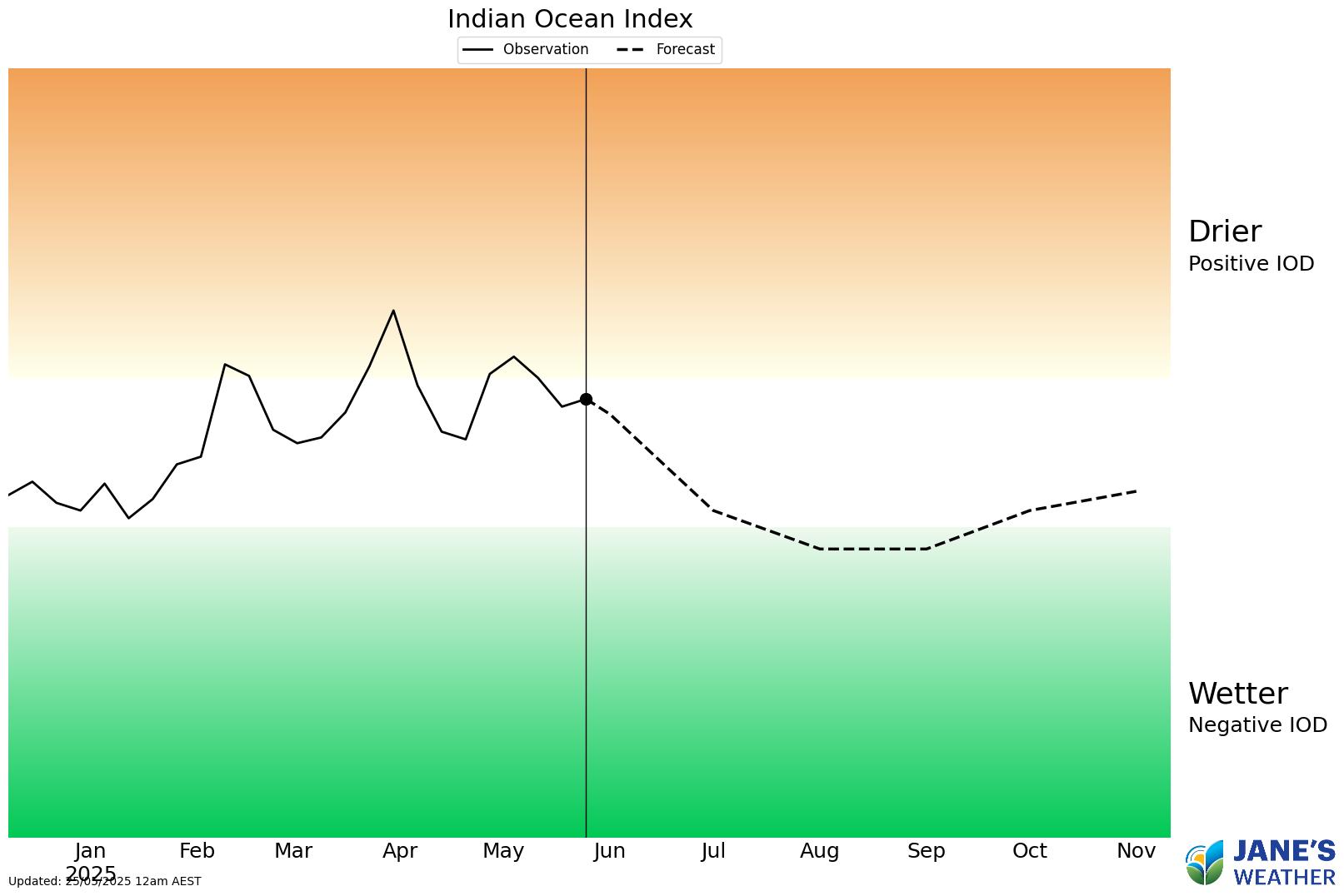
Looking further afield, and eagle eyes will have seen the hint of a change in the Indian Ocean box over the past fews weeks. Now there is a lot more blue developing, and that is the catalyst for a big shift in the Indian Ocean.
We already have warm water between Indonesia and northwestern Australia, and the current rain systems have tapped into that to bring big falls where high pressure doesn't block it - but this change in the Indian Ocean steps it up further.

The forecast is for the recently 'Positive', and now on the 'Positive side of Neutral' ocean to rapidly head towards 'Negative' and cross the threshold, as we go through June and July.
This increases that push of moisture from the northwest - it enhances those big, juicy northwest cloud bands.
The question is - will the highs move out of the way to let low pressure meet up with that moisture?
There is some hope, as a Negative Indian Ocean Dipole does encourage the highs to become less dominant... so the future may be looking a lot brighter (ie wetter!).
For an in depth analysis, here is this week's video:
In this series I'll take you through the drivers of our weather, highlighting any changes over time and things to watch out for (generally every Sunday). It covers weather elements like temperature and rainfall, and how they are driven by moisture from the Pacific and Indian Oceans, as well as bursts of energy from low pressure (SAM and MJO).
See and hear my commentary as I take you through the weather pattern's effects on our rain and temperatures in detail over the next week, with a brief look at week 2 and beyond as well.
Plus what is driving our weather in the weeks and months ahead, with the latest on El Nino/La Nina, the Indian Ocean Dipole (IOD), the Southern Annular Mode (SAM controls our weather systems), and the Madden Julian Oscillation (MJO connects tropical moisture to our weather systems).
I update this commentary each week, generally on Sundays. Make sure you are signed up (free or a subscription) so you don't miss an update.
Stay up to date with the forecast specifically for your area in our hour by hour outlook for the next 10 days. Download our app for iPhone and Android.
As always, you can see each of these graphics as soon as they update, as well as more information about them under our Rain Outlook and Seasonal Outlook pages within Jane's Update, along with our Snow Forecast in the snow season.

For further insights specifically for agriculture, to improve the utilisation of your resources, tailored to any Australian location, please upgrade your membership. You can take advantage of our free 30 day trial.
Upgrade to see full insights to help plan the best use for your resources:
- frost risk
- spraying conditions
- evapotranspiration to efficiently manage available water for crops
- growing degree days to monitor growth
- full ten day hour by hour outlooks, all variables, and all model data
- customised alert notifications
.png)
.png)
.png)