
.png)

Cyclone Fina has well and truly dissipated, but she has left behind a ball of moisture sitting up over the northern Kimberley.
These ‘leftovers’ are now a source of fuel for other weather systems, ensuring that they bring a lot more rain than they otherwise would.
It’s always the luck of the draw as to which weather systems the moisture meets up with, and this time it is southeastern Australia that wins that lottery.
Southeast SA, the majority of Victoria, far southern NSW and western and northern Tasmania are going to see not one but two weather systems enhanced by this moisture feed. They pass through on Friday into Saturday, and again on Sunday through to Tuesday - with this last one having a double punch with cold air as well. Expect widespread falls of 25 to 50 mm, with 10 to 25 mm for much of southeast SA, southern NSW and northwest Victoria.
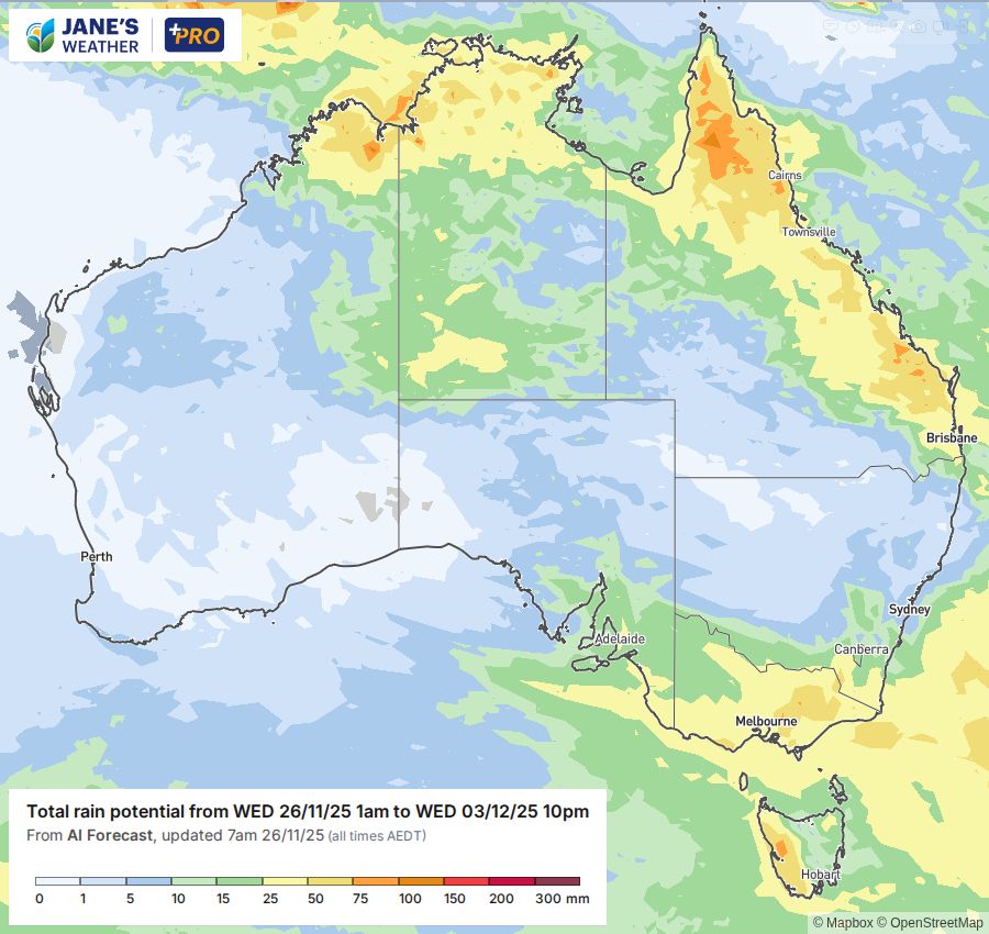
Meanwhile, persistent troughs and a feed of moisture from the Pacific Ocean are ensuring that parts of Queensland and northeast NSW are in the firing line for severe thunderstorms, that keep redeveloping day after day.
The current wave of activity slowly retreats northwards to finish the week, with northeast NSW and southeast Queensland quite dry and sunny by Friday, but the next burst isn’t far away, as it redevelops over the weekend.
In amongst this is a persistent heatwave that extends down across Queensland and NSW, and with the wind picking up too there is increased fire danger.
We are a land of drought and flooding plains, and the extremes of our weather can be huge, from snow in Tasmania, to heavy rain in Victoria, heatwave and fire danger in NSW and giant hail in Queensland.
While all this focus is on the east of the country, the southwest is rather quiet under the influence of high pressure. The position of the high controls the temperature and while this week is on the mild side, that will change over the weekend as the high moves eastwards and temperatures rise. Perth goes from the low 20s to high 30s in just a few days, with the heat peaking early in the new week.
That high moving eastwards means that the incredibly active weather over eastern Australia will take a break next week (from early in the week in the north, and from mid week in the south), before the next bout of weather systems kicks off once again.
.png)
.png)
