

An intense low pressure system is located over the Bight, ready to send a cold front over the southeast on Monday, followed by a second trough on Tuesday.
There are a few things to note here:
- We haven't seen pressure this low, or this intense in a long time. Conditions over the southeast have been generally calm for an extended period, as high pressure dominated the weather pattern - so this is a huge change in terms of wind effects.
- Lower pressure enables more rain to fall! In order to make it rain you need moisture and instability - this is the instability part of the equation.
- High pressure is still having an impact though... as the ridge stretching from southwest of Perth right across the country to the waters off Brisbane (look on the map and go from the Hx1027 across to the Hx1020) means that there is a block - and all that tropical moisture flowing into the northwest of the country isn't connecting with the system in the south. This means that the rain will decrease as you head inland.
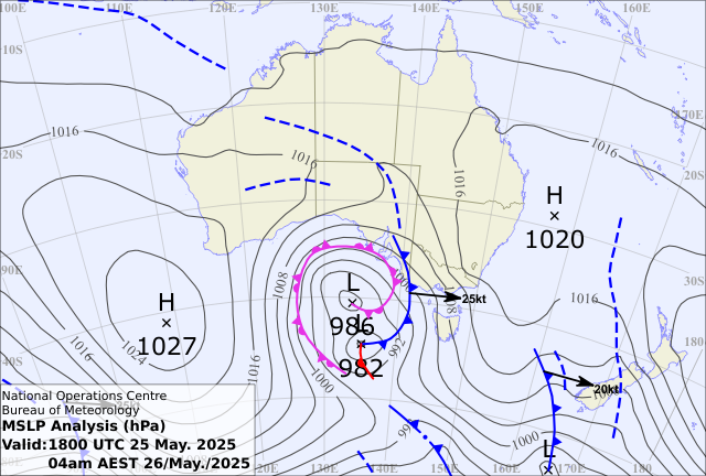
So, the rain that is coming in from the Indian Ocean across northwestern Australia, isn't going to connect with the southeast system, and while the intense low, cold front and trough bring rain, it will decrease as it moves inland.
What it will do is bring a cold outbreak. You can see how cold the air is on the satellite - shown by the speckled cloud over the Bight. The cold front will be a big one, and the edges of this chilly airmass will make it right up to southern Queensland by mid week.
This also means that we go into another stretch of frosty nights (only inland this time, as cloud and showers will persist near the coast in the southeast).

The yellow areas on the map show just how widespread the severe weather warning stretches over land. This is for damaging winds, grading to destructive over elevated parts. These will ease during Tuesday as the weather system moves away and high pressure moves in.
We also have Strong to Gale Force marine wind warnings from Esperance right through to Newcastle, and Coastal Hazard Warnings for damaging surf and erosion, and low lying flooding from abnormally high tides in SA and Victoria.

We'll have a bit of rain, a lot of wind and coastal impacts, then it all eases.
.png)
%20(1920%20x%201080%20px)%20(2).png)
.png)