A complete guide to using Jane's Weather
Account Settings
When you sign up it takes you to your account settings page.
User Profile
Edit information associated with your account. Change your name, profile picture (this appears in the top right of each screen), email address and password, and complete your user profile. Click Contact Us to get in touch.
Membership
Upgrade to a Premium, Business or Snow Season membership to access our full features, and purchase a video session with Jane Bunn for a full analysis of the weather in your location.
Locations
Paying subscribers can set an unlimited number of different locations, anywhere that suits you across Australia.
The forecast graph and 'super alert' will show the data for your favourite location, and the forecast maps (when launched) will have your favourite spot front and centre.
Free Members can only save one location.
Alerts and Notifications
Paying subscribers have access to our alerts notification service.
The 'super' alert is for your favourite location, and is automatically sent to you each day. Amend the settings here to change that schedule.
Set up customised alerts for any location - ie Only show me when winds could gust over 60km/h, or when temperatures fall below 5C, or when rain is possible over 1mm/hr or 10mm/day.
Each alert is displayed under the notifications bell (top of the screen) as well as sent to your email inbox.
Forecast - Graph
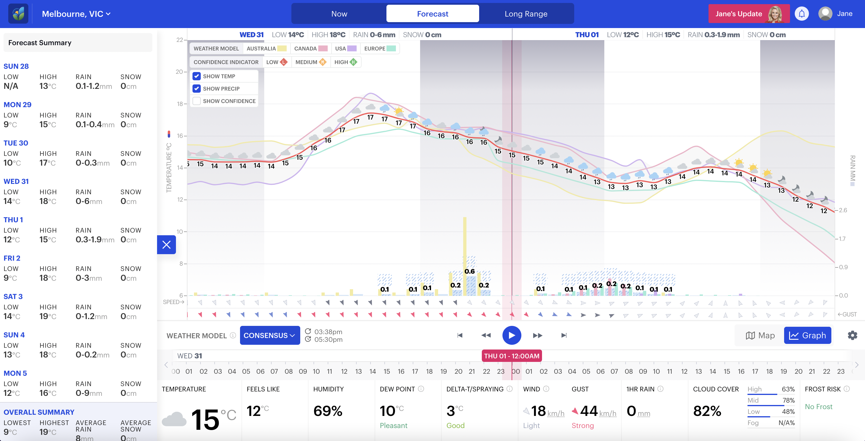
Select the location you wish to see the forecast for in the top left (your favourite location is automatically selected). Then choose from the different global weather models we have so far: EURO, AUSTRALIA, CANADA and USA or our blend of them all, the CONSENSUS.
Weather observations from across the globe (from satellites, radars, airplanes, ocean buoys etc) go into a supercomputer, where extensive mathematical equations churn through all that data. After about 4-6 hours, they compute an answer. This answer is the weather forecast; a different one for every square on earth.
Each model uses their own mathematical equations, so the answer can differ from model to model. And each model has a different resolution of these squares. USA has one answer for every 28km square, CANADA has one for every 22km square, EURO for every 20km, and AUSTRALIA 12km.
In AEST you can expect a new forecast:
- from USA around 3am, 9am, 3pm and 9pm each day
- from CANADA around 4am and 4pm each day (it only runs twice)
- from EURO around 6am, 11:30am, 6pm, 11:30pm (the 11:30am/pm run only updates the first three days, the remaining days are from the earlier run)
- from AUSTRALIA around 6am, 11:30am, 6pm, 11:30pm (the 11:30am/pm run only updates the first three days, the remaining days are from the earlier run)
Jane's Weather Consensus takes each of these weather models and combines them for you into one forecast. This means you are always covered by the complete picture, and you're not relying on just one weather model. What if that one model is having a bad day, or saying something completely different to the others? Our Consensus makes sure you're not affected by poor data.
The summary of each day's highs and lows, and how much rain or snow is possible, is shown up the top and on the left hand side (click the box on the left hand side).
The graph shows you temperature as it moves through time, along with an icon. If there is rain or snow possible, it is shown in a bar at the bottom of the graph area. The wind direction is displayed, along with the speed (the average over time), and the gust (the peak wind/the strongest it gets).
This is supported by data at the bottom of the screen, that changes as you step through time.

A note on showers and thunderstorms: A shower or storm icon indicates that this type of convective wet weather is a risk in your area during that time period. It doesn't mean that it will continuously rain or even rain at all, rather there is a risk of activity during each of those hours. The rainfall amount can indicate when they are most likely, and if they could bring heavy rain. That's why showers and storm icons always have sun as part of the symbol.
Thunderstorms are always the 'potential for storms', they are never a guarantee that they will occur. They show risk in the area, not specifics.
Jane's Update
Get the latest information directly from Jane, updated at various times during the week.

Rain Forecast - maps updated twice daily - takes you through the potential rainfall across the country. Until we launch our maps, this is a good summary of all the weather models, to indicate what rain is possible day by day. Soon we will have each model's maps showing rain/cloud/temperature etc hour by hour, centred on your spot. For now, watch my video update every Monday and Thursday morning (sent directly to paying subscribers).
Seasonal Outlook - indicators updated daily to weekly - takes you through a selection of indicators that drive our weather in the weeks and seasons ahead. Week two's rainfall is in there, a handy heads up for the time period after the day to day weather models stop, as well as the next two month's outlook. This follows what is happening in the Pacific Ocean, the Indian Ocean, SAM (our cold fronts, lows and troughs) and MJO (tropical moisture to really make it rain).
Snow Forecasts - Jane's commentary updated daily during the ski season. Read all about our snow forecasts here.
7NEWS photos: instructions on how to show Jane the weather in your area. They could be shown on 7NEWS tonight.
Suggestions: let us know what works and what doesn't, and what features you would like to see next.
Help Centre: articles explaining how the features on the site work.