.png)

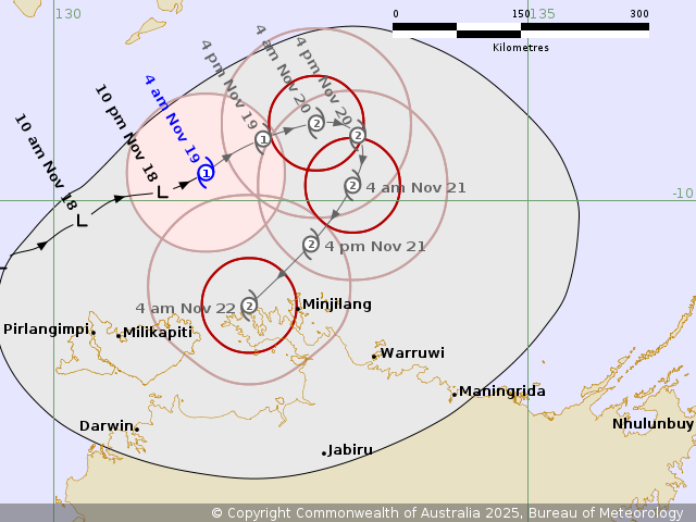
Our first cyclone of the season has formed north of Darwin: Cyclone Fina.
These beasts can have two phases - the big build up and crossing of the coast producing sometimes catastrophic effects for those in its path; and then we’re stuck with the “leftovers”.
Tropical Cyclones are essentially similar to our regular low pressure systems (as a ‘low’ is technically a cyclone, and a ‘high’ is technically an anti-cyclone), but when they form over waters above 26C in a favourable atmospheric environment, then they turn into a tropical system and develop into beasts that are rated by their category (1 as the weakest and 5 as the strongest) depending on how much havoc they can cause if they cross a coastline.
Cyclone Fina may be hundreds of thousands of kilometres away from you, but it can have an impact on your weather over the next couple of weeks - thanks to the “leftovers” that it leaves behind.
Just like on Boxing Day and beyond how you will take what is left over from Christmas and repurpose that food into a new dish, the left over moisture and energy from a cyclone can be the new ingredients in other weather systems.
Once the beast makes landfall it loses access to its source of energy - the ocean - and it starts to weaken. But such a big and powerful system doesn’t dissipate straight away, and these “leftovers” can crowd our weather pattern (and your fridge) for quite some time.
If Cyclone Fina crosses the coast (and even if it doesn’t and continues roaming the oceans) then we have a big ball of energy and moisture that has the potential to feed into another weather system.
Any trough, low or cold front that crosses southern Australia, or any trough that takes up residence in the eastern states, has the potential to be fed by these “leftovers” - and that turns a regular weather system into something that can produce a lot of rain.
We’ve already seen big sources of moisture in winter and spring thanks to the Negative Indian Ocean Dipole that encourages moisture from the Indian Ocean to be funnelled into our weather systems - and anyone in the path of these gets more rain than that weather system would usually bring.
We’re beginning to see big sources of moisture from the Pacific Ocean thanks to a near or weak La Nina as we go through spring and summer - and, thanks to the considerably warmer than average water that surrounds the majority of the country, big sources of moisture whenever the airflow into a weather system is onshore.
This will be another big source of moisture that could turn a garden variety weather system into a significant rain system. But as always it will all depend on that connection being established, and where the weather system moves.
.png)