
.png)

The weather pattern looks very different to recent weeks.
We always look at where the Low pressure is, to see who is getting the rain, but it’s important to consider where the High’s are sitting too.
One of the High’s is east of New Zealand, and the other is so far to the west of Perth it is practically off the weather map.
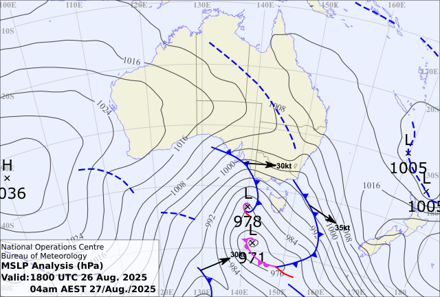
This ensures there is a big gap in the middle, over Australia, that lets Low pressure run wild.
The first feature was a band of rain on a cold front. Tropical moisture from the Indian Ocean fed into this band, and when we have both moisture and instability working together it produces widespread rain. Without High pressure blocking the way this rainband was able to travel from one side of the country to the other, affecting WA, SA, Victoria, Tasmania and NSW.
This is just the first in a series of disturbances that will keep coming through to the weekend.
Cold front after cold front rises up from the Southern Ocean and crosses some part of the south.
The trajectory of these is important as to what the air feels like. If the front has peaked back to the west and it moves across your spot coming down from the northwest, then it’s cool not cold. If the isobars in behind the front are running vertically north/south, then it’s a very different story.
These fronts bring air from near Antarctica, and it depends on how short the trip is, as to how much time it has to thaw out. When the winds are southwesterly behind a front then it's chilly, but when they are southerly then the trip is very short, and the air is absolutely bitter.
Perth experienced this at the start of the week with a top temperature of just 11C. Melbourne feels one of these on Friday into Saturday, when it’s likely to barely reach 12C.
Low level snow accompanies the cold air, not just on the alps but on the lower hills too, along with wintry hail - the tiny balls of ice that bounce when they hit the ground. It may be late August but the weather pattern doesn’t play by the rules!
A series of cold fronts is a great vehicle for the rain to add up. Over the course of four to five days there should be widespread falls of 20 to 50 mm - more about elevated and exposed parts (locally over 100mm) - less about far inland parts (but still 5 to 20 mm).
.jpeg)
And while the rain doesn’t reach the east coast (on the dry side of the ranges this time), or Queensland, the bite in the wind certainly will.
.png)
.png)
